Tadaris · تضاريس · Geospatial data
Find, share and use every map your government holds.
Tadaris (تضاريس, “terrain”) gives a government one platform for its geospatial data. Custodians publish datasets with AI-assisted metadata and quality checks, users find and use them on a map or through OGC APIs, GeoAI models detect change, and the digital twin shows plans in 3D before they are built. Open data reaches the public through its own portal.
- One catalogue for datasets and services
- OGC APIs and standards-based sharing
- GeoAI and a 3D digital twin
Tadaris · Geoportal
OGC APIDatasets
1,284
Custodians
46
API calls today
218K
- Road centrelines · DS-04121,240 edits validated · version 14Published
- Population grid 100 m · DS-0877AI metadata drafted · quality gate 2 of 3In review
- Building footprints · tilesOGC API Tiles endpoint liveLive
Authorized vendor to
- Ministry of Finance
- Ministry of Interior
- DGE Abu Dhabi
- Etihad Aviation
- EDGE Group
Delivered for
- Hindustan Unilever
- Nokia
- Linde
- USA Today
- JSL
Procurement-ready
- Abu Dhabi Government Procurement Gate
- UAE Ministry of Finance, federal procurement
- Registered ADNOC vendor
- National ICV certificate
Product tour
See Tadaris at work
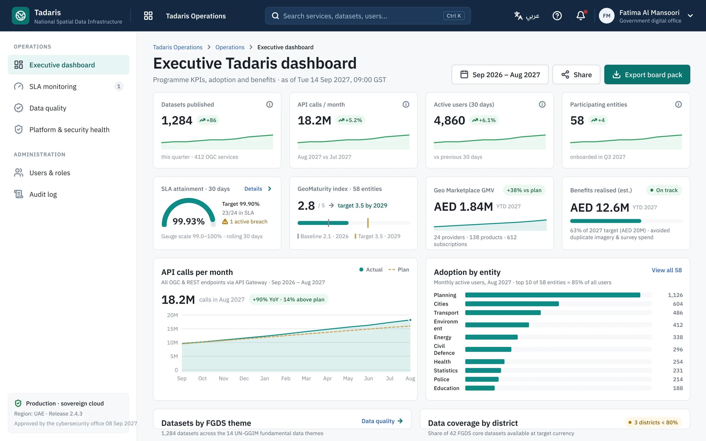
Screens from Tadaris, shown with sample datasets and entities.
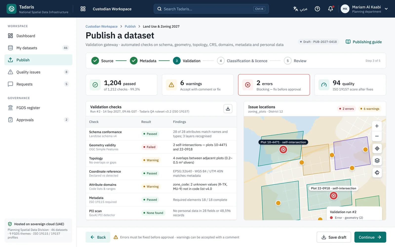
Quality before publication
Errors block publication and warnings need a comment, so the catalogue stays trustworthy.
Standards built in
OGC APIs, ISO 19115 metadata and the UN-GGIM themes are part of the platform, not an add-on.
Adoption you can measure
See which entities use which datasets and APIs, and what that is worth.
Why it matters
Geospatial data that nobody can find
Every entity keeps its own maps, so data is duplicated, out of date and hard to share, and decisions are made without it.
Hidden in silos
Datasets sit on separate servers with no shared catalogue or metadata.
Quality nobody can vouch for
Users can’t tell which version is authoritative or when it was last updated.
Slow to share
Each request for data becomes an email thread and a file transfer.
What Tadaris does
A complete spatial data infrastructure
Discover and search
One catalogue for datasets, services and maps, browsable by the UN-GGIM fundamental data themes, with a map viewer.
Custodian publishing
Upload data, let AI draft the metadata, pass validation and quality gates, and publish with versions.
Developer portal and APIs
OGC APIs, keys and documentation, so systems use live data instead of copies.
Quality and SLAs
Quality controls, data currency and service availability tracked for every dataset.
GeoAI studio and assistant
Models such as change detection with approval and MLOps governance, and questions answered in plain language.
Data marketplace
A catalogue of data products with pricing, licensing and subscriptions for providers and users.
Urban digital twin
A 3D and 4D viewer with IoT, BIM and utilities, and scenarios such as shadow and flood.
Open geodata portal
Public datasets, open data policy, consultations and feedback in one place.
Learning and field app
Courses and certification for staff, and a mobile app for inspectors in the field.
How it works
From a custodian’s upload to every user
- 01
Publish
Custodians upload datasets; AI drafts metadata and validation checks quality.
- 02
Discover
Users across government find authoritative data in the catalogue and on the map.
- 03
Use
Systems connect through OGC APIs, and analysts apply GeoAI models and the digital twin.
- 04
Open
Approved datasets reach the public through the open data portal, with feedback.
Who it’s for
Built for those who own the map
Spatial data authorities
National and emirate-level bodies that coordinate geospatial data.
Municipalities and planning
City planning, land and infrastructure departments.
Utilities and data custodians
Entities that publish and maintain authoritative geospatial datasets.
Licensing
License Tadaris on your servers or in the cloud
Tadaris is sold as a software licence, not a one-off project. You choose where it runs; the product, updates and support are the same.
On-premise licence
Runs on your servers
Install Tadaris in your data center, in your private cloud tenant or on an isolated network with no internet connection.
- Annual licence, priced by the number of users and published datasets
- Your data never leaves your network
- Installation, training and updates included
- Support with agreed response times
Cloud subscription
Hosted for you
We run Tadaris for you in a UAE data center, or in a cloud region in your country, ready in days.
- Monthly or annual subscription, priced by the number of users and published datasets
- Hosting, backups and monitoring included
- Updates applied for you
- Single sign-on and role-based access
The price depends on the number of users and published datasets and the support level. We reply within one business day and send a written quote after a short scoping call.
Track record
Trusted by UAE government entities and global brands.
Authorized vendor to five UAE government entities, with projects delivered for Hindustan Unilever, USA Today, Nokia and Linde.
- Startups and enterprises served by our engineering teams
- 150+
- Startups and enterprises served by our engineering teams
- Average rating on Clutch, Trustpilot and Glassdoor
- 4.9/5
- Average rating on Clutch, Trustpilot and Glassdoor
- Client satisfaction rate
- 98%
- Client satisfaction rate
- UAE government entities we are an authorized vendor to
- 5
- UAE government entities we are an authorized vendor to
Hear it from our clients
Client testimonial
E-commerceClient testimonial
HealthcareClient testimonial
E-commerceClient testimonial
E-commerce
Security
Standards-based and secure
Open standards
OGC-compliant services and APIs, so data works with the tools you already use.
Classification and access
Data classification and role-based access, with sign-in through UAE PASS or single sign-on.
Governed AI
GeoAI models are approved before use and monitored in production.
Your servers or UAE cloud
On your servers or in a UAE cloud, aligned with government cybersecurity requirements.
Book a demo
See Tadaris publish and share a dataset
We walk your team through a sample upload with AI metadata, the catalogue and map viewer, an OGC API call, a GeoAI change detection and the digital twin, in Arabic or English.
- A live demo, not slides
- Mapped to your datasets and custodians
- Under NDA if you need one
4.9/5 average rating · 98% client satisfaction · 150+ clients served
FAQ
Geospatial data questions, answered
What is Tadaris?
Tadaris is a geospatial data platform, or spatial data infrastructure. It gives a government one catalogue to publish, find and use geospatial data, with OGC APIs, GeoAI, a data marketplace, an urban digital twin and an open data portal.
Does it replace our GIS software?
No. Tadaris sits on top of the GIS tools your teams use, publishing and sharing their data through standards-based services and APIs.
How does AI help custodians?
When a custodian uploads a dataset, AI drafts the metadata and validation checks flag quality issues before publishing. GeoAI models, such as change detection, are approved before use.
Which standards does it support?
OGC services and APIs, with catalogues organised around the UN-GGIM global fundamental geospatial data themes.
Can the public use it?
Yes. Approved datasets can be published on the open geodata portal, with open data policies, consultations and feedback.
Does it work in Arabic?
Yes. The portal, the custodian workspace and key journeys work in Arabic and English, right to left.
How is Tadaris licensed?
As an annual on-premise licence installed on your servers, private cloud or an isolated network, or as a monthly or annual cloud subscription that we host in a UAE data center or a cloud region in your country. Both include updates and support.
Put your government’s maps to work
Book a live Tadaris demo for your geospatial team.
Book a Tadaris demo